-
 Jaiswal slams majestic 161 but Australia fight back in Perth
-
Edinburgh's alternative tour guides show 'more real' side of city

-
 IPL teams set to splash the cash at 'mega-auction' in Saudi Arabia
-
Olympics in India a 'dream' facing many hurdles

-
 Wounded Bangladesh protesters receive robotic helping hand
-
Majestic Jaiswal 141 not out as India pile pain on Australia

-
 Giannis, Lillard lead Bucks over Hornets as Spurs beat Warriors
-
Juan Mata agent slammed as 'cowardly' by angry A-League coach

-
 Marta inspires Orlando Pride to NWSL title
-
Palestinian pottery sees revival in war-ravaged Gaza

-
 Main points of the $300 billion climate deal
-
Robertson wants policy change for overseas-based All Blacks

-
 Israel retreat helps rescuers heal from October 7 attack
-
Afghan women turn to entrepreneurship under Taliban

-
 Mounting economic costs of India's killer smog
-
At climate talks, painstaking diplomacy and then anger

-
 Uruguayans head to polls with left hoping for comeback
-
Trump's mass deportation plan could end up hurting economic growth

-
 Iran director in exile says 'bittersweet' to rep Germany at Oscars
-
US consumers to bargain hunt in annual 'Black Friday' spree

-
 Cheers, angst as US nuclear plant Three Mile Island to reopen
-
Scientists seek miracle pill to stop methane cow burps

-
 Australia ditches plans to fine tech giants for misinformation
-
Developing nations slam 'paltry' $300 bn climate deal

-
 Red Bulls win 'Hudson River derby' to reach conference final
-
Neuville wins world title after Tanak crashes at Rally Japan

-
 Neuville wins world rally title after Tanak crashes in Japan
-
Colapinto cleared for Las Vegas GP despite heavy crash

-
 'Smiling One' Amorim vows he has ruthless streak Man Utd need
-
Marseille down Lens to stay in touch with Ligue 1 leaders, Lyon draw

-
 New Zealand beat 'proud' Italy in Cane's Test farewell
-
Barca collapse in Celta draw without Yamal, Simeone hits milestone

-
 Thailand's Jeeno equals Yin for lead at LPGA Tour Championship
-
New Zealand beat Italy in Cane's Test farewell

-
 Marseille down Lens to stay in touch with Ligue 1 leaders, Lyon held to draw
-
Liga leaders Barca suffer late collapse in Celta draw

-
 Retegui fires Atalanta top of Serie A ahead of Inter
-
Greaves hits maiden Test century as West Indies dominate Bangladesh

-
 Venezuela opposition calls for mass anti-Maduro protest on Dec. 1
-
'Fragile' Man City in uncharted territory, admits Guardiola

-
 Erasmus hails Springbok strength in depth after thrashing Wales
-
Postecoglou calls for consistent Spurs after Man City rout

-
 'We've never lived this situation' admits Guardiola
-
Lebanon says more than 55 killed in Israeli strikes

-
 'We've never lived this situation' admits Guardiola as Man City lose five in a row
-
Under-fire Gatland 'motivated' to continue as Wales coach

-
 South Africa send Wales crashing to 87-year low in Test rout
-
Spurs condemn Man City to fifth straight defeat as Arsenal win

-
 Defeated Leipzig lose more ground on Bayern, Frankfurt go second
-
South Africa put Wales to the sword to wrap up season


'Unsurvivable' Hurricane Helene races towards Florida
Parts of Florida face "unsurvivable" conditions when Hurricane Helene hits later Thursday, the US weather service said, warning that howling wind will drive destructive waves and storm surge as high as 20 feet (six meters) onto the low-lying coast.
Residents fled ahead of the incoming hurricane amid mass evacuation orders.
The fast-moving storm was a Category 2 mid-morning Thursday, the National Hurricane Center (NHC) in Miami said, packing wind speeds of 105 miles (169 kilometers) an hour as it churns over the warm waters of the Gulf of Mexico.
The NHC said Helene -- which it described as one of the largest Gulf hurricanes in recent decades -- is expected to make landfall at or near Florida's Big Bend coast in the evening and could develop into a Category 3 or 4.
Tampa and Tallahassee airports have already closed, and Florida Governor Ron DeSantis urged residents to rush preparations ahead of the "nasty" storm.
It's a "very dangerous hurricane," NHC director Mike Brennan said.
"We're expecting to see a storm surge inundation of 15 to 20 feet (4.5-six meters) above ground level," he said. "That's up to the top of a second story building. Again, a really unsurvivable scenario is going to play out here in this portion of the Florida coastline."
"In addition to that storm surge, you're going to have destructive wave action on top of that, that can destroy houses, move cars, and that water level is going to rise very quickly," he said. "Winds are going to penetrate well inland."
The NHC warned of up to 20 inches (51 cm) of rain in isolated spots, and potentially life-threatening flooding as well as "numerous" landslides across the southern Appalachians further inland.
Several states are in the potential path. Georgia's capital Atlanta, a metropolis of some five million people, is forecast to experience tropical storm-force winds and as much as 12 inches (30.5 cm) of rainfall, which authorities warn could bring flash flooding.
Most of Georgia, which like Florida is under a state of emergency, was placed on flood watch, while Tennessee -- more than 300 miles (482 km) from the Gulf Coast, is bracing for tropical storm conditions statewide.
The White House said President Joe Biden's administration "stands ready to provide further assistance to Florida, and other states in the path of the storm."
DeSantis mobilized the National Guard and positioned thousands of personnel to prepare for possible search and rescue operations and power restoration.
- Sandbags, boarded windows -
The hurricane warning encompasses a 250 mile (202 km) stretch of coastline from Tampa Bay to Panama City, on the Florida panhandle.
A direct impact was likely in the Tallahassee region, where coastal communities already looked like ghost towns by Wednesday afternoon.
In Crawfordville, potentially in the storm's direct path, wheelchair-bound residents of the Eden Springs Nursing and Rehab Center were evacuated by bus.
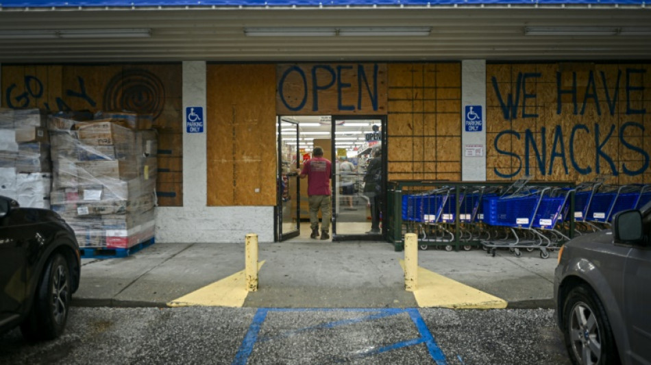
Other locals loaded up on gas and supplies, filling sandbags and boarding up homes and businesses.
"I expect the water to come up and just don't want it to get in the house," Clearwater Beach resident Jasper MacFarland told AFP, as he built a barrier with sandbags to "keep as much water out of the house as possible."
Helene could become the most powerful hurricane to hit the United States in more than a year.
Category 3 Hurricane Idalia hit northwestern Florida in August 2023.
Meanwhile Hurricane John, which killed three people when it slammed into Mexico on Monday but then dissipated, regained hurricane strength Thursday and was expected to again strike the country’s Pacific coast, Mexican officials said.
At 1200 GMT John was 56 miles (90 km) from the southern port city of Lazaro Cardenas in Michoacan state and was packing winds of 71 miles an hour (115 kmh), the NHC said.
Researchers say climate change likely plays a role in the rapid intensification of storms, because there is more energy in a warmer ocean for them to feed on.
burs-mlm/sms
Y.Bouchard--BTB


